
We drove south out of Adelaide onto the Fleurieu Peninsula, a stubby peninsula which includes Goolwa, Victor Harbor, Port Elliot, Yankalilla, Normanville, Cape Jervis, McLaren Vale, and the inland hills around Mount Compass. The scenery is rolling farmland, vineyards, rugged cliffs, long surf beaches, and the wetlands of the Lower Murray. Its name honours the French explorer Charles Pierre Claret de Fleurieu, reflecting the area's early surveying, the French being interested in the area (1800) decades before the British colonisation.
Why come to Goolwa??? For one reason only, and that was to see the mouth of the River Murray, which rises in the Snowy Mountains of NSW as small alpine streams on the Great Dividing Range near Mount Kosciuszko, at about 1430m elevation and meanders 2508km until it runs into the Southern Ocean. The Murray empties into the huge Lake Alexandrina and then flows again through the Coorong to its mouth. We have been all along this river, but never this final destination!
The town has a long high street featuring two pubs, both of which we patronised for dinner, but its heart as far as visitors are concerned is Goolwa Wharf. The wharf area is overlooked by a dramatic huge bridge to Hindmarsh Island opened in 2001 replacing a cable-ferry (a punt). Goolwa Beach, only a few km from downtown, is a splendid long sandy stretch, and features a boardwalk climp up to whale-watching lookout. We did not see a whale, but there was reportedly a mother and calf offshore "yesterday", of course.
We were fortunate to encounter the Goolwa Market, a weekly riverside mix of local produce, crafts, food stalls and community energy that seemed to be well attended even in mid-winter.
The Spirit of the Coorong...
The Coorong is a long, narrow lagoon system running southeast from Goolwa. It's a 140-km stretch of sheltered water separated from the Southern Ocean by the sweeping dunes of the sandy Younghusband Peninsula. It joins a wetland complex supporting hundreds of bird species, including migratory shorebirds that travel from as far as Alaska. The name Coorong is an anglicised form of the Ngarrindjeri word "kurrangk", meaning "long, narrow neck" which is entirely appropriate.
Much of the Coorong is that part of the Murray below the last (well, first, because it is numbered #1) lock on the river, and it includes the actual mouth of the Murray as it flows into the Southern Ocean. We did a cruise on the Coorong with maybe a dozen other passengers. Our vessel was a catmaran called the Spirit of the Murray, our skipper was Jesse, and the mate was Alicia. Lunch was included, a surpise to us because we had had a sandwich before boarding! It was a delicious salad, and we asked Alice to keep it in the fridge so we could have it for dinner in our boathouse. The Spirit passed (just, a very tight fit) through the #1 lock which is part of a barrage across the river, a dam maintaining a certain water level upstream and in Lake Alexandrina. Because the whole area is a maze of islands, there are numerous barrages.
The cruise was very worthwhile, notably for the birdlife we encountered, and for a pleasant 750m walk across Younghusband to the ocean, ably guided by Alicia, who showed us aboriginal middens and, with her bare feet, how the traditional owners caught pipis. The only other cruise we saw in action from Goolwa seemed to be on the elderly side-wheeled paddle-steamer Oscar W. It did one hours trips around town and up the river, but it would have been too wide to pass through the barrage lock into the Coorong.
Before European interference, the Murray Mouth was open and tidal, and the daily rise and fall of the sea propagated inland, with tidal influence reaching Wellington SA, ~70 km upstream from Goolwa, water levels in what is now Lake Alexandrina rose and fell with the tide. Lake Alexandrina and others were not "lakes" in the modern sense — they were broad estuarine lagoons. In dry years, seawater pushed well into Lake Alexandrina. In wet years, the lakes became mostly fresh. The system breathed with the climate. This variability supported a mix of freshwater and estuarine species — a very different ecology from today's strictly freshwater lakes upstream of the barrages. Goolwa was a river port.
Goolwa was always as far as river traffic could safely go. The Mouth was tricky, dangerous and unreliable, so to transport goods to ocean going vessels, a railway was built (one of the first in Australia) to Port Elliot (1854), then Victor Harbour (1864), a safer harbour.
A series of barrages were built in the 1930's because upstream irrigation and regulation had reduced natural flows so much that, the lakes were becoming too saline for towns and farms, the Murray Mouth was closing more frequently, navigation was unreliable, droughts caused extreme salinity spikes, and the estuary was no longer functioning as it once had. The barrages insulated upstream from the salinity of the ocean.
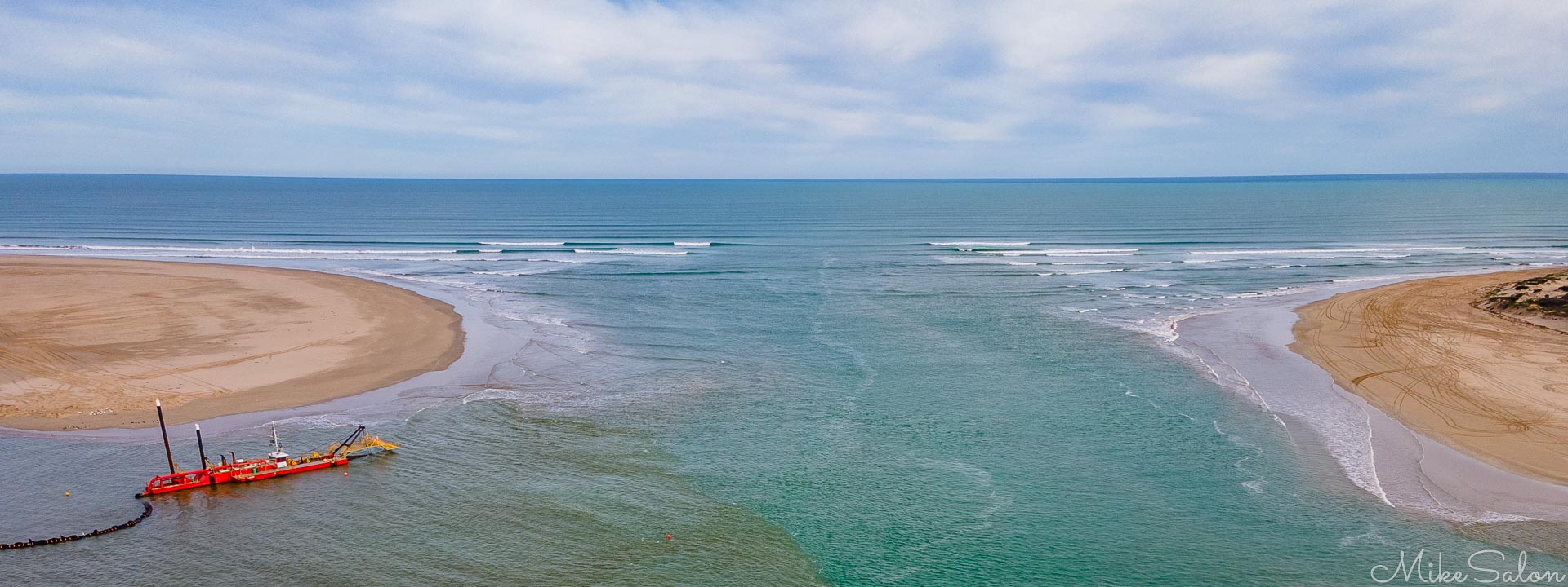
At the very Mouth is a suction-dredge working to keep it open. It has run almost 24/7 since 2002, and is needed because the Murray-Darling River system is now so heavily regulated that sesonal floods do not exist, and gradual sediment buildup will close it. An open mouth allows tidal exchange between the ocean and the Coorong lagoons, maintaining salinity balance and oxygen levels vital for fish, birds, and other critters. The pipeline has become a regular resting place for New Zealand Fur Seals, so named because that is where they were first "described" by science (~1775, during James Cook's second voyage), not where they live.
A Haven for Birdlife
The quest for photogenic birds goes on. Photographing birds around the Coorong has been a rewarding challenge — a place where the familiar meets the elusive. My lens has captured many of the region's regulars: pelicans gliding over lagoons, darters drying their wings, cormorants skimming the surface, and honeyeaters flashing through coastal scrub. Yet, the Coorong's quieter residents — the secretive rails, bitterns, and tiny thornbills — remain hidden to us, probably best found with the help of local expertise, time and patience, all of which we have in limited quantities only. The Goolwa experience reminds us that bold, large birds invite the camera, while the rare and timid ones demand time, persistence and a touch of luck.
A River Town on the Beach
Goolwa is one of those privileged towns which enjoys river/lake and ocean beach frontages. It fronts a magnificent stretch of sand, which merges seamlessly eastward into Younghusband Peninsula and the Coorong Beach. Together they form one continuous sandy barrier running from the Murray Mouth all the way to Kingston SE — roughly 190km long, Australia's longest continuous beach.
Goolwa Beach sports a few cafes, a surfclub, plus a timber boardwalk, protecting rather fragile looking dunes, which climbs up to an elevated whale watching spot. Regrettably, vehicles are allowed onto the beach east of the surfclub. We spotted no whales even though it's the season, but, naturally, we were told there was a mother and calf lazing there "yesterday".
Birks Marina Boathouse...
Our stay in Goolwa was at Birks Marina Boathouse, a great find on the internet. It occupied most of the building which was effectively the marina office because it had an amenities room for boaties, one of whom we met, grumbling about how the diesel in this stinkboat had gone stale. Our boathouse was just superb, spacious, packed (probably too much) with boating memorabilia, and, best of all, a pot-bellied wood stove equipped with a generous serving of ultra dry kindling and redwood. We enjoyed three very cosy evenings thanks to this fire. Our hosts, who live over the road, were away, so we didn't meet them, due to family illness. Our access key was under the mat - obviously Goolwa is an honest town - and a more high-tech solution, like a coded lock-box, hasn't been felt necessary yet. The boathouse was provisioned with enough breakfast goodies to keep us going through our stay. We could not have done better but to stay here, and there was the added bonus that it entitled it to a 10% discount on the Sprit of the Coorong cruise.
Fish & Chips on Hindmarsh Island...
The bridge to Hindmarsh Island has transformed it. Before 2001 it was a quiet farming community reached only by a slow cable punt, which kept development modest and the island slightly isolated. Once the bridge opened, access became effortless, and the island's long waterfronts suddenly became prime real estate. We saw large marina-style estates development, with artificial canals and lagoons. Lots of waterfront houses and moored-houseboats too. The bridge also made the Murray Mouth dramatically more visible and accessible, turning what was once a remote viewpoint into one of the region's most striking coastal panoramas.
From the cruise, we had noted what looked like a cafe operating out of shipping containers more or less opposite the Mouth, so we went out of our way to find it in our car. We enjoyed fish and chips and a beer at this informal establishment. It was 2pm, and they were rapidly running out of anything to cook! But plenty of booze.
Around Lake Alexandrina...
To better appreciate the beauty and size of Lake Alexandrina, we drove around it on exit from Goolwa. It is huge, some 580km2, but shallow. Remember, it was once a tidal estuary. Alex is the largest permanent freshwater lake in SA, one of the largest permanent lakes in Australia. It is only dwarfed by huge salt-pan lakes like Eyre which are often dry anyway. We paused in localities such as Clayton Bay, Milang, Wellington and finally Murray Bridge, as we skipped away from the lake.
Milang was interesting. We discovered a railway museum there, and saw from the rusty tracks that it was the intersection between a broad gauge system (a branch of South Australian Railways, 1884-1970) and a narrow gauge system ( 1884-1920, a tramway which connected lake merchant vessels to the state railway network).
And we saw the punt at Wellington, still running 24 hours a day. Wellington is well upstream of the Murray Mouth, but it had tidal effects until the barrages went in. Signage told us this crossing was on the route from the Victorian goldfields to Adelaide in the 1850's. And that four punts have sunk here in bad conditions (floods and sand), the latest being in 1958.
Footnote, my admission of truth ...
The captions and titles on the images are mine, and I take responsibility for them. But I'm no naturalist, so the identification and descriptions of fauna and flora mostly comes from sources like local guides, Wikipedia, e-Bird, Merlin or artificial intelligence agents like Gemini or Copilot. It is fabulous to have those resources available!